Soil moisture sensors: 5 ways to optimize Bekaa irrigation
The Bekaa Valley runs on a steadily compounding hydrological deficit. The valley accounts for roughly 42% of Lebanon’s cultivated land and more than 70% of the country’s potato acreage, yet around 65% of its irrigation is drawn from groundwater.
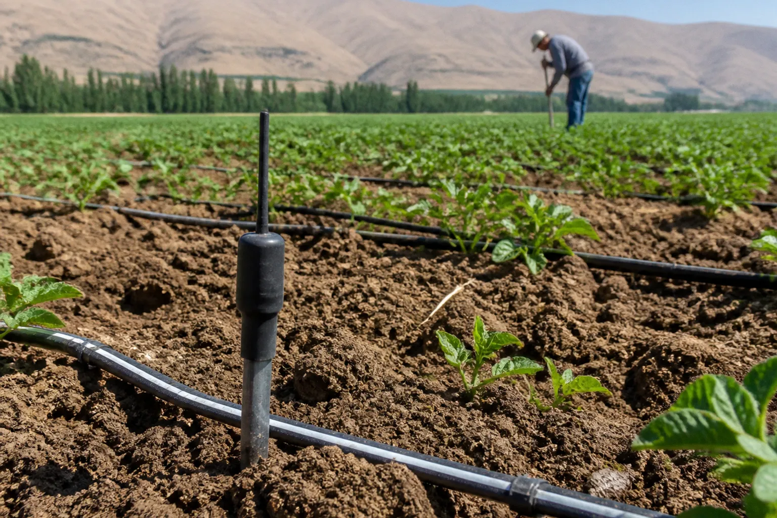
In several sub-regions, the water table has dropped by more than 15 meters over five years. Every additional cubic meter therefore carries a higher embedded cost in diesel, pump wear, electricity, and labor.
The operational question is no longer whether to irrigate. It is how to turn each pumped liter into a measurable amount of crop output per hectare.
A soil moisture sensor irrigation system in Lebanon does not solve groundwater depletion by itself. It does something more practical: it makes the relationship between pumping, root-zone moisture, and crop demand visible. Probes installed at representative depths can support manual decisions or trigger automated valves. Either way, they replace a fixed calendar with a record of what the soil is actually holding.
That distinction matters in the Bekaa. A schedule based on habit may work tolerably on one part of a field and waste water on another. Clay-loam, gravelly alluvial soil, different rooting depths, uneven pressure, and changing crop demand rarely fit the same irrigation interval.
Sensor arrays do not deliver water; they convert pumping capital into a metric that can be audited per hectare per day.
Mitigating groundwater depletion in the Bekaa Valley
1. Establish the baseline before installing the hardware
The first way to optimize irrigation is not to buy a sensor. It is to document the system that the sensor is supposed to improve.
Many farms still organize irrigation around fixed rotations, pump availability, or the operator’s visual reading of the crop. During peak demand, a block may be irrigated for several hours and then left to dry for a number of days. That approach is understandable when labor, electricity, and water access are uncertain. It is also difficult to audit. At the end of the season, the farm may know how much fuel it purchased, but not how much water reached the active root zone or how much passed below it.
A useful baseline should connect four records:
- Pump operation: running hours, start and stop times, fuel or electricity consumption, and any pressure or flow irregularities.
- Irrigation delivery: the number of blocks served, valve opening times, emitter or sprinkler type, and approximate discharge.
- Soil response: moisture readings at relevant depths before and after irrigation.
- Crop condition: growth stage, visible stress, disease pressure, and any yield or quality variation between parts of the field.
This is where cooperatives have an advantage. A single farm may not have enough equipment or staff to maintain a reliable measurement routine. A cooperative can standardize the form, train one technician, and compare blocks that use similar pumps, crops, and irrigation equipment. The result is more valuable than an isolated reading because it begins to show which losses are caused by scheduling and which are caused by the hydraulic system itself.
A soil moisture sensor is not a magic meter that tells an operator to irrigate every time the number falls. It is a way of observing the movement of water through a specific soil profile. The number only becomes useful when it is connected to field capacity, the crop’s root depth, and the time required for the wetting front to reach the intended zone.
2. Map variation inside the field
The second way is to stop treating every hectare as hydraulically identical.
Bekaa plots can change from heavier clay-loam sections to lighter or gravelly alluvial soil over short distances. The same irrigation cycle will not behave in the same way across both. Water may remain available longer in one section and drain rapidly in another. A crop can therefore show no visible stress while water is being lost below the roots, or show localized stress even though the block has received what appears to be a sufficient volume.
The first installation decision is consequently not the brand of probe. It is the location of the probe.
Sensors should represent a management zone with a recognizable combination of soil, crop, slope, irrigation equipment, and rooting depth. A probe placed beside a road, near a pump house, or in an unusually wet corner will produce a technically correct reading that is operationally misleading. The same is true of a probe installed only near the surface when the main crop roots extend much deeper.
For a field using drip lines, the sensor should be positioned in relation to the wetted bulb rather than simply placed midway between rows. For a sprinkler system, the operator needs to account for the distribution pattern and any overlap. In either case, the location must be recorded and left undisturbed so that later readings remain comparable.
A practical deployment can use several depths within the same representative zone:
- A shallower probe to show how quickly the surface layer dries.
- A probe within the main active root zone to guide the irrigation decision.
- A deeper probe to indicate whether water is reaching below the intended profile.
The exact depths should follow the crop and soil rather than a universal template. Potatoes, vines, and stone fruit do not draw water from the same profile. The lower sensor is particularly useful because it can reveal over-irrigation before the operator sees standing water or runoff. If moisture continues rising below the productive root zone after the crop has been replenished, the system is spending water on drainage.
This is the point at which precision agriculture in Lebanon becomes less about sophisticated dashboards and more about correct field placement. A simple, well-positioned sensor can improve a decision more than a dense network that measures the wrong part of the plot.
Lessons from the ILO BOUZOUR project and pilot farms
The ILO’s BOUZOUR project, funded by the Swedish International Development Cooperation Agency, installed sensor-based irrigation and fertigation systems across 15 pilot farms in the Akkar and Bekaa regions. The pilot combined soil-moisture measurement with irrigation controls and communication equipment. Its relevance lies in the operating model: irrigation was treated as a sequence of measurable decisions rather than as a fixed number of hours assigned to each block.
The available lesson from the pilot is not that every farm should reproduce one hardware package. It is that a farm needs a feedback loop.
A useful loop has five parts:
1. Measure the root zone. Read moisture at a depth that corresponds to the crop’s active roots.
2. Define a refill point. Decide how dry the profile can become before irrigation begins.
3. Set a stopping condition. Stop when the target layer has been replenished, not when a customary timer has completed.
4. Record the event. Store the moisture reading, valve opening, pump runtime, and any manual override.
5. Review the result. Check whether the lower profile stayed within the target range and whether the crop responded as expected.
The BOUZOUR experience should therefore be read as an operational demonstration, not as a universal savings table. Farm results depend on pump efficiency, borehole depth, soil texture, emitter condition, crop stage, and the discipline with which workers follow the schedule. A change that saves water on one block may reduce crop performance on another if the threshold has not been calibrated.
The same caution applies to diesel. Sensor control can reduce unnecessary pumping, but the actual result must be calculated from the farm’s own logs. A pump lifting water from a deep borehole is not comparable with a pump drawing from a shallow source. Nor is a well-maintained pump comparable with one operating under worn seals, blocked filters, or unstable pressure.
Fertigation requires the same discipline. Applying nutrients during a long, poorly controlled irrigation cycle increases the risk that soluble nitrogen or potassium moves below the active root zone. Sensor data cannot replace agronomic advice, but it can help the operator identify when the soil is approaching saturation and when an application is likely to move beyond the crop’s reach.
The useful output of a pilot is not a headline percentage. It is a repeatable operating routine that a farm can measure again next season.
Turning a pilot into a cooperative service
For small and medium-sized producers, the cooperative model is more realistic than asking each farm to build a complete technical department. The cooperative can purchase a limited number of field kits, maintain a shared calibration protocol, and offer installation support during the critical stages of the season.
That shared service could include:
- Initial soil and irrigation-zone mapping.
- Sensor installation and protection against farm machinery.
- A common schedule for reading and checking probes.
- Training for pump and valve operators.
- Monthly review of water, energy, and irrigation records.
- Removal, storage, and recalibration of equipment between seasons where needed.
This also prevents a common failure mode: installing sensors but continuing to irrigate exactly as before. If no one has authority to change the schedule, the system becomes an expensive display rather than a control layer.
Scaling precision irrigation: the Château Kefraya wireless network
The transition from pilot scale to commercial production is visible at Château Kefraya in the West Bekaa. The estate operates a wireless sensor network across roughly 300 hectares in collaboration with Libatel, Ogero Telecom, and USJ-ESIAM. The network continuously monitors soil moisture and microclimate conditions, including variables such as air temperature, relative humidity, leaf wetness, and solar irradiance.
The important fact is the continuity of observation across a large commercial area. A sensor network at this scale is not simply a collection of isolated probes. It creates a common record that can be used to compare fields, identify unusual drying patterns, and revisit irrigation decisions as conditions change.
The configuration details that matter for other farms are the principles rather than a fixed technical blueprint.
Use zones instead of pretending to measure everything
Full spatial coverage is rarely necessary. A farm can divide its land into zones that share similar soil, crop, topography, and irrigation behavior, then place representative stations where they will answer a real management question.
The zone boundaries should not be drawn only from cadastral maps. They should reflect the farm’s operating reality:
- Where does the soil change?
- Which blocks receive water at different pressure?
- Which areas dry first?
- Where do workers report recurring crop stress?
- Which fields are supplied by different wells or pumps?
- Are different varieties or rootstocks being managed together?
This approach keeps the network useful without implying that one reading describes every plant. A representative station is a management aid, not a substitute for field judgment. It should be checked periodically against manual observations and, where possible, against readings from additional temporary probes.
Treat telemetry as a management record
Continuous monitoring is valuable only if someone acts on it. The network should support a daily or weekly decision process, depending on the crop and the season. A cooperative or estate manager can review whether moisture is falling as expected, whether an irrigation event reached the lower target depth, and whether a valve or pump appears to have behaved differently from the schedule.
The review should also flag implausible readings. A sensor that reports no change after a long irrigation event may be disconnected, badly placed, or outside the wetted area. A sensor that shows an abrupt jump without a corresponding valve event may need inspection. Data quality is not a side issue: an unreliable reading can produce more waste than no reading if it gives the operator false confidence.
Weather information can be useful in this layer, but it should be treated as a decision input rather than an automatic command. A forecasted rainfall event may justify delaying an irrigation cycle, but the decision should account for forecast uncertainty, soil storage, crop sensitivity, and the likelihood that rainfall will actually reach the root zone. The sensor tells the manager what is already in the soil; the forecast helps estimate what may arrive next.
Evaluate scale with the right costs
A commercial network includes more than probes. The budget may cover wireless nodes, gateways, installation labor, communications, protective enclosures, valve controls, software, maintenance, and staff time. A credible investment case should list those costs separately and compare them with measured changes in:
- Pump runtime.
- Fuel or electricity use.
- Water pumped or applied.
- Emergency irrigation events.
- Crop losses associated with water stress.
- Labor spent checking and changing valves.
- Repair frequency in pumps and irrigation equipment.
There is no responsible universal payback period for this equipment. Installed cost and savings vary too widely between farms. A cooperative should calculate a local payback scenario only after collecting a baseline and should present it as a farm-specific estimate, not as a result guaranteed by the technology.
Integrating sensors with renewable energy and mobile controllers
3. Separate monitoring from pumping power
A field sensor does not need to be powered in the same way as a pump. That distinction is important in areas where the grid is unreliable or where diesel generators are used for irrigation.
The monitoring layer generally has modest energy requirements compared with pumping. It can therefore be designed around a small solar-charged battery system, provided the equipment is protected, the communications link is reliable, and the autonomy requirement is realistic for the site. The valve-control layer must be assessed separately because actuators, gateways, and communications equipment may have different demand profiles.
The system should be designed around a clear hierarchy:
- Sensors measure soil and microclimate conditions.
- A field controller stores or receives the irrigation logic.
- Valves execute the decision.
- A mobile interface allows the operator to review data, approve changes, or intervene.
- The pump system supplies water according to the hydraulic demand.
A mobile controller is useful because it shortens the distance between measurement and action. A manager does not need to be at the pump house to see that a zone has reached its refill point or that a valve has failed to open. But remote control also creates a new obligation: every manual override must be logged. Otherwise the data will show a moisture change without explaining why it happened.
4. Build for failure, not just for connectivity
Wireless agricultural systems are exposed to dust, heat, rodents, machinery, weak cellular coverage, and battery degradation. The system should continue in a safe mode when the communications link fails. That may mean holding the last approved schedule, limiting the duration of an irrigation event, or requiring local confirmation before reopening a valve.
The fallback procedure should be known by the field team. Workers need to know how to:
- Check whether a sensor is transmitting.
- Confirm that a valve actually opened.
- Read the field manually when telemetry is unavailable.
- Pause automated irrigation.
- Restart the system after a power interruption.
- Record a manual event for later entry into the farm log.
Renewable power can reduce dependence on diesel for the control architecture, but it does not eliminate the need to maintain the hydraulic system. Solar panels will not compensate for leaking lines, blocked filters, incorrect pressure, or worn emitters. Energy and water efficiency have to be treated as connected but separate problems.
5. Make mobile data useful to people in the field
A dashboard that displays dozens of graphs may impress a procurement committee and still fail during harvest. The operator needs a small number of actionable signals: which zone is approaching its lower limit, which zone did not respond to irrigation, which valve did not confirm its position, and which sensor requires inspection.
The interface should also preserve historical context. A single reading has limited meaning. A trend across several wetting and drying cycles is more useful because it shows how quickly the soil loses available water and how long irrigation takes to restore the target profile.
For a cooperative, a shared platform can provide a common language across member farms. The data does not need to be identical in every field, but the definitions should be consistent. “Irrigation completed” should mean more than “the pump ran”; it should indicate which zone was served, for how long, under what pressure, and with what soil response.
Achieving water savings through micro-irrigation calibration
The most important saving may come from the equipment downstream of the sensor. A reliable moisture reading cannot correct a badly calibrated irrigation network.
Emitters, mini-sprinklers, filters, pressure regulators, pipes, and valves determine how the water reaches the soil. If pressure varies along a line, some plants receive more than the schedule assumes and others receive less. If filters are partially blocked, the operator may extend the irrigation event to compensate, increasing the imbalance. If the application rate exceeds the soil’s infiltration capacity, water begins to run off or move below the active root zone before the crop can use it.
This is why a target such as up to 40% water saving should be treated as an illustrative benchmark for a properly designed and calibrated system, not as a guaranteed outcome of installing sensors. The result must be measured against the farm’s own baseline and confirmed without compromising yield or quality.
Calibrate the hydraulic system before trusting the schedule
A calibration exercise should connect the controller’s instructions with the actual delivery in the field.
The operator can begin by checking pressure at representative points along the irrigation line, measuring discharge from selected emitters or mini-sprinklers, inspecting filters, and confirming that valves open and close fully. The soil response should then be observed at the sensor depths after an irrigation event.
The objective is not to make every part of a complex farm identical. It is to understand the difference between commanded irrigation and delivered irrigation. If a controller reports that a zone ran for a set period, the manager should know approximately how much water that represented and where that water went.
The schedule can then be adjusted around field capacity and the refill point:
- Irrigate before the crop reaches avoidable stress.
- Stop before the lower profile receives water that the crop cannot use.
- Allow enough time for the intended wetting pattern to develop.
- Recheck the lower probe after the event.
- Change one part of the schedule at a time so the result can be interpreted.
A sensor should not be used to chase a constantly rising moisture number. The target is a stable root-zone condition that matches crop demand, soil storage, and the next expected irrigation opportunity.
Connect irrigation to crop stage
Crop demand changes during the season. Potatoes during tuber development do not have the same water requirement as vines at another stage of growth. The schedule should therefore include crop stage rather than relying on one threshold for the entire season.
The threshold can be reviewed when:
- The canopy expands significantly.
- The crop enters a reproductive or yield-forming stage.
- Harvest approaches.
- Temperatures and wind conditions change.
- Roots occupy a larger portion of the profile.
- The field is exposed to a different disease or quality risk.
This does not require an elaborate model. It requires the farm manager to understand why the threshold is being changed and to record the reason. A controller that changes settings without a corresponding note makes later analysis difficult.
Measure the saving instead of declaring it
The correct question is not whether the system is advertised as saving 40%. It is whether the farm pumped less water for the same acceptable crop result.
That comparison requires a baseline period and a consistent measurement method. Depending on the infrastructure, the farm may use a flow meter, pump operating records, tank or reservoir levels, or another defensible proxy. The method should remain stable throughout the comparison. Fuel use should be logged separately from water because a shorter irrigation event does not automatically translate into the same percentage reduction in diesel consumption.
The farm should also monitor what happens to yield, crop quality, disease incidence, and labor. A reduction in pumping that creates uneven growth is not an efficiency gain. Similarly, a system that saves water but requires constant manual intervention may be unsuitable for a cooperative with limited technical staff.
The useful performance statement is therefore specific to the farm: water applied per hectare, pump runtime per hectare, and crop output under the revised schedule. Any projected savings before that measurement should be presented as a target or scenario.
From isolated devices to an operating system
The five practices are connected:
1. Map the baseline before choosing equipment.
2. Place sensors according to soil and root-zone variation.
3. Use measured thresholds to guide irrigation rather than relying only on fixed calendars.
4. Connect telemetry, controllers, and renewable power without ignoring failure modes.
5. Calibrate delivery hardware and verify the result through farm records.
Leaving out one of these practices weakens the rest. A well-placed sensor cannot compensate for blocked filters. A wireless network cannot compensate for a schedule no one reviews. A solar controller cannot compensate for a leaking line. A promising water-saving target cannot substitute for a measured comparison.
The cooperative model is particularly relevant because the technical burden does not end with installation. Someone has to inspect the probes, maintain the communications equipment, verify valves, interpret the readings, and keep the records clean enough to support a seasonal decision. Shared technicians and shared procurement can make that work possible for farms that could not justify a complete system individually.
Verdict: measure the next liter before pumping it
The case for soil moisture sensor irrigation in Lebanon is not built on technology enthusiasm. It is built on the need to make water use visible in a valley where groundwater is under sustained pressure and pumping costs rise as wells deepen.
The ILO BOUZOUR pilot demonstrates the value of linking moisture measurement with irrigation control and farm-level operating discipline. Château Kefraya shows what continuous monitoring can look like when the approach is extended across a large commercial estate. Renewable-powered controllers and mobile interfaces can make the system more resilient, but only if the underlying hydraulic network is calibrated and maintained.
Claims about water savings, diesel reduction, or payback should remain farm-specific until they are supported by local records. An advertised benchmark of up to 40% water saving may be a useful planning target for a properly calibrated micro-irrigation system, but it is not a guaranteed result. The same caution applies to energy use: pump depth, equipment condition, pressure, crop stage, and operator behavior determine the outcome.
The practical decision for a Bekaa cooperative is therefore straightforward, even if the installation is not. Start with the pump log and the field profile. Measure where the water goes. Install enough sensors to represent the real variation in the land. Link each irrigation event to a recorded soil response. Then expand only when the first zones produce evidence that the system is improving the operation.
That is how smart farming in Lebanon becomes infrastructure rather than another disconnected gadget: one measured hectare, one calibrated zone, and one accountable irrigation decision at a time.