Rainwater harvesting in the Bekaa: a pond construction plan
The Bekaa Valley cannot afford to treat water storage as an optional farm upgrade.
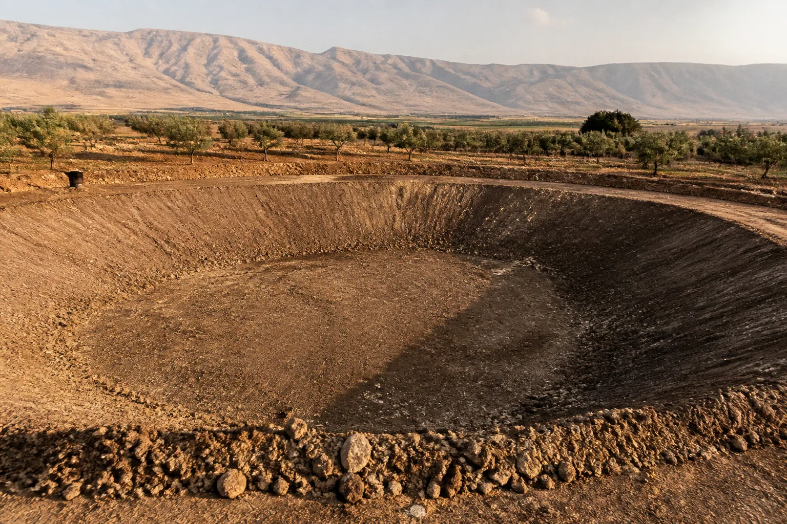
The valley covers approximately 150,000 hectares, around 80% of which is irrigated, and the wider Upper Litani River Basin supports roughly 42% of Lebanon’s agricultural production. When groundwater levels fall and seasonal rainfall runs off the land without being captured, the result is predictable: higher pumping pressure, unreliable irrigation windows, and more exposure to drought.
Rainwater harvesting ponds in the Bekaa Valley are not a stand-alone cure. They are storage infrastructure. Their value depends on the full system around them: catchment design, safe earthworks, sediment control, drip irrigation, crop scheduling, and disciplined water accounting. Build the pond without those controls and you have an expensive hole. Build the system as a whole and you gain a buffer against dry periods while reducing pressure on groundwater, the Litani basin, Qaraoun Lake, and the Ammiq Wetland.
The operating case for farm ponds in the Bekaa
The basic logic is simple:
- Capture rainfall when it arrives.
- Slow runoff before it leaves the farm.
- Store usable water outside the peak rain event.
- Release it through an efficient irrigation network.
- Reduce dependence on groundwater pumping during the most stressed part of the season.
Lebanon’s renewable freshwater resources are estimated at about 4,100 million cubic metres per year under average precipitation conditions. That represents roughly 1,000 cubic metres per person annually for a population of 4.3 million. Those figures describe national availability, not guaranteed farm access. A grower in the Bekaa still faces local depletion, uneven rainfall, damaged infrastructure, competing demand, and water quality risks.
That is why the correct question is not, “How large should my pond be?” The correct question is, “How much clean water can my farm capture, store, and deliver to crops without compromising the site or the downstream catchment?”
The answer depends on five variables:
1. Catchment area: How much land, roof surface, road edge, or drainage channel contributes runoff?
2. Rainfall pattern: Is water arriving in a few intense events or in smaller, more frequent storms?
3. Soil infiltration: Will the reservoir hold water, or will it lose volume through seepage?
4. Sediment load: How quickly will eroded soil reduce storage capacity?
5. Irrigation demand: Which crops need water, at what growth stages, and through which delivery system?
A pond that fills quickly but loses water through seepage is not efficient. A lined reservoir that remains clean but has no controlled inlet is not resilient. A large storage basin connected to flood-prone slopes is a liability.
A farm pond is not the water strategy. It is the storage component of a water strategy.
Start with the catchment, not the excavation
The most common planning error is to select a low point on the farm and start digging. That reverses the sequence. First map the water movement. Then select the storage location.
For a practical farm pond design in Lebanon, begin with a site walk after a significant rainfall event if possible. Track where water concentrates, where sediment deposits, and where runoff bypasses the field. Mark natural channels, field roads, terraces, field boundaries, buildings, wells, septic systems, and existing irrigation lines.
Build the site file
Before requesting excavation quotes, assemble a basic site file containing:
- A topographic survey with elevation points across the proposed catchment and reservoir footprint.
- The estimated contributing area and its slope direction.
- Soil information from the reservoir floor, embankment zone, and inlet route.
- Existing drainage paths and flood-prone sections.
- The location of wells, springs, buildings, roads, power lines, and property boundaries.
- The intended irrigation command area.
- A preliminary sediment-control and overflow route.
Do not rely on visual judgement alone. A shallow depression may look ideal but may have permeable soils, unstable sides, or an outlet that sends overflow toward a neighbouring property. A hillside site may offer excellent gravity flow but require much more complex earthworks.
Use contour swales to control the inflow
Catchment swales are shallow contour-aligned earthworks that slow runoff and distribute it across the landscape. They are not substitutes for the reservoir. They are the first line of defence.
Use them when:
- Slopes are sending fast runoff toward the pond.
- Soil erosion is carrying fine sediment into the storage basin.
- The farm has enough contour length to spread water before it reaches the inlet.
- You need to increase infiltration in selected areas rather than route every drop directly into storage.
The operational sequence should be:
1. Intercept runoff high in the catchment.
2. Reduce flow velocity through contour structures and vegetated strips.
3. Route excess water through a defined, protected inlet.
4. Drop sediment before water enters the main reservoir.
5. Keep a separate emergency overflow route away from buildings and unstable slopes.
If the swale fills with sediment, it is doing its job. Maintain it before the next wet season. If water cuts around the swale, the alignment, outlet, or protection is wrong and must be corrected before increasing the inflow to the pond.
Select the reservoir site using four tests
A suitable site must pass hydrological, geotechnical, operational, and safety tests. A low purchase price or convenient location is not enough.
1. Hydrological test
The site must receive enough runoff to justify construction without creating a flood hazard. Review the catchment, not just the pond footprint. Roads, compacted farm tracks, rooftops, and neighbouring slopes may contribute water during heavy storms. That additional runoff can increase both yield and risk.
If the catchment is too small, the reservoir may remain underfilled. If the catchment is too large, the inlet and embankment may face destructive peak flows. In the second case, add controlled diversion, sediment interception, and a protected spillway. Never assume the embankment itself can safely act as the overflow path.
2. Geotechnical test
Test the soil where the pond will hold water and where the embankment will be built. Soil texture, compaction behaviour, rock layers, cracks, and permeability all affect the design.
If the soil has adequate natural retention, an earth reservoir may be possible with properly compacted layers and protected slopes. If the soil is highly permeable or fractured, a liner may be required. The correct liner type and thickness depend on the site investigation, water quality, exposure, installation method, and expected mechanical stress. There is no responsible universal thickness to specify without those inputs.
Do not allow excavated soil to be classified as suitable embankment material by appearance alone. Material must compact consistently and remain stable under wetting and drying cycles.
3. Operational test
The reservoir should connect cleanly to the irrigation network. If the pump, filtration unit, and mainline are far from the pond, the system will carry avoidable energy and maintenance costs. If the site is below the fields, gravity distribution may reduce pumping demand. If it is above the command area, check pressure management and erosion risks in the delivery network.
Leave room for:
- Access by maintenance equipment.
- Sediment removal from the inlet zone.
- Inspection of the embankment and liner.
- Pump and filtration equipment.
- Safe fencing where people or livestock may enter.
- A future connection to additional storage or a second irrigation block.
4. Safety and downstream test
Overflow is not a minor detail. It is the failure mode you must design first.
The emergency spillway should direct excess water through a stable, protected route. Keep it away from the embankment core unless the design has been engineered specifically for that purpose. Protect discharge points against erosion. Do not route overflow toward homes, public roads, neighbouring fields, electrical infrastructure, or natural wetland areas.
The Ammiq Wetland, the Litani River, and Qaraoun Lake are already under ecological stress. A poorly managed reservoir can transfer sediment, nutrients, and contaminated runoff downstream. Water conservation must reduce pressure on the basin, not shift the damage to another location.
Engineering the pond: earthworks, liners, and sediment control
Reservoir construction should be treated as a sequence of controlled operations. The sequence matters because mistakes made during excavation are difficult and expensive to reverse.
Strip and store the topsoil
Remove fertile topsoil from the reservoir footprint and stockpile it separately. Do not bury it in the embankment. The topsoil can later support vegetation on selected external slopes and disturbed areas, but it is not a reliable structural material for the water-retaining zone.
Clear roots, organic debris, loose material, and unsuitable fill from the foundation area. Organic matter decomposes and creates weak zones. Roots can also damage liners or form seepage paths.
Shape the basin for maintenance
Avoid sharp corners, inaccessible shelves, and irregular pockets that trap sediment. The reservoir needs a defined inlet zone, a main storage area, and a point where accumulated sediment can be removed.
The basin profile should support:
- Safe access for inspection.
- Stable side slopes.
- Easy installation and protection of the liner where required.
- Minimal dead storage below the usable intake level.
- Separation between incoming sediment and clean water drawn for irrigation.
A sediment forebay is one of the highest-value additions to a small reservoir. It is easier to clean a shallow, accessible sediment trap than to excavate the entire pond after storage capacity has been lost.
Compact earth in controlled layers
For an unlined or partially lined reservoir, compaction quality determines performance. Place suitable soil in controlled layers and compact each layer to the required standard. Do not use a single thick lift and assume the machinery has compressed the full depth. Surface firmness can hide weak material underneath.
Inspect for:
- Cracks along the embankment.
- Settlement after the first filling.
- Wet spots or seepage on the downstream face.
- Erosion at the inlet and spillway.
- Uneven liner support.
- Animal burrows or root penetration.
The first filling should be managed, not rushed. Raise the water level progressively while inspecting the structure. A staged fill gives the operator time to identify settlement, seepage, and deformation before the reservoir reaches its maximum operating level.
Choose a liner based on the site, not a catalogue headline
A lined reservoir can reduce seepage where soils cannot retain water reliably. But a liner only works if the base preparation, anchoring, joining, drainage control, and protection layers are correctly executed.
Before selecting a liner, confirm:
- The soil is smooth and free of sharp rocks.
- The foundation is compacted and stable.
- Water will not build pressure beneath the liner.
- The liner edges have a secure anchoring detail.
- Seams are installed and tested according to the material system.
- Exposed surfaces are protected from puncture, sunlight, livestock, and maintenance traffic.
- Repairs can be carried out without draining the entire reservoir.
The unknowns around private farm pond construction costs and liner specifications in North and South Bekaa are significant. Do not accept a quote that lists only excavation and liner area. Request separate line items for survey work, soil preparation, inlet protection, sediment control, spillway construction, liner installation, fencing, pump equipment, filtration, and commissioning.
That breakdown exposes false savings. A cheap liner over a badly prepared floor is not a low-cost system. It is delayed failure.
The cheapest cubic metre of storage is the one that survives the first storm, the first dry season, and the first maintenance cycle.
Connect the pond to an irrigation system that can ration water
Storage does not create efficiency. Distribution does.
A reservoir connected to open channels or leaking lines will simply convert captured rain into avoidable losses. For vegetables, orchards, and other high-value crops, use a controlled delivery system with filtration and zone management. Drip irrigation is especially important where water must be allocated carefully across different crop blocks.
The irrigation network should include:
- A screened or protected intake.
- A pump sized for the actual elevation and flow requirement.
- Filtration matched to the emitter system.
- Pressure regulation where terrain changes across the farm.
- Isolation valves for each irrigation block.
- Flush points at line ends.
- A simple meter or monitoring method to track withdrawals.
- Protection against air locks and sediment entry.
If the pond receives runoff from roads, livestock areas, or intensively treated fields, test water quality before using it on crops. Sediment can block filters. Nutrient-rich or contaminated runoff can create crop, soil, and food-safety problems. A clean catchment is part of the irrigation system.
Apply an if-then operating protocol
Use a written protocol instead of relying on memory during the irrigation season.
- If the reservoir level is high after the wet season, then prioritise deep percolation support, orchard establishment, or planned crop demand without increasing irrigation beyond agronomic need.
- If the water level falls below the agreed operating threshold, then reduce irrigation frequency, prioritise high-value or vulnerable blocks, and review crop-stage demand.
- If turbidity increases after a storm, then isolate the intake temporarily, allow sediment to settle, and inspect the forebay and inlet protection.
- If groundwater pumping is still rising despite full pond storage, then audit distribution losses, irrigation timing, crop selection, and unauthorised withdrawals.
- If the spillway activates, then inspect the inlet, embankment, downstream channel, and any erosion immediately after the event.
- If seepage appears on the downstream face, then stop treating it as normal moisture and obtain a structural inspection before raising the water level.
This is where many water projects fail. The infrastructure exists, but no one has defined the trigger points for changing operations.
Combine pond storage with regenerative field practices
The pond should not carry the full burden of climate adaptation. Improve the land that feeds it.
A resilient Bekaa farm combines storage with practices that keep water in the soil for longer:
- Maintain soil cover between crop cycles where agronomically appropriate.
- Use compost or other approved organic amendments to improve soil structure.
- Reduce unnecessary tillage that leaves soil vulnerable to erosion.
- Keep vegetated buffer strips along drainage lines.
- Use contour planting on sloped ground.
- Integrate cover crops where they fit the crop rotation.
- Protect beneficial habitat and field margins that support biodiversity.
- Reduce pesticide use through monitoring and targeted intervention rather than routine application.
- Separate clean roof runoff from polluted farmyard runoff.
These measures reduce the volume and speed of runoff, which helps the reservoir in two ways. More water infiltrates where the soil can store it, while the runoff that reaches the pond carries less sediment. That extends the life of the storage basin and reduces maintenance.
For organic agriculture, water quality and input records must also remain traceable. Rainwater is not automatically clean because it falls from the sky. The collection surface, surrounding land, storage condition, and irrigation method all influence the risk profile.
Work with the Green Plan and institutional programmes
Large-scale hill lakes and agricultural ponds in North Bekaa are managed through the Council for Development and Reconstruction and the Green Plan, with financing from grants including support from the French Development Agency. UNDP and KfW have also supported hill lakes and agricultural ponds in vulnerable communities across areas such as Bekaa and Baalbek-Hermel.
For a cooperative, this matters because shared infrastructure can outperform scattered private ponds. A cooperative can aggregate demand, coordinate maintenance, standardise water-quality monitoring, and justify stronger technical planning. It can also negotiate around the catchment rather than limiting the project to a single farm boundary.
When approaching an institutional programme, prepare a technical package rather than a general request for funding. Include:
1. The cooperative’s member farms and total irrigated area.
2. Crop types and seasonal irrigation windows.
3. A map of proposed catchments and storage sites.
4. Current groundwater dependence and pumping constraints.
5. The proposed inlet, sediment-control, spillway, and distribution system.
6. A maintenance plan with named responsibilities.
7. A water allocation rule for dry-season shortages.
8. Environmental safeguards for downstream waterways and wetlands.
9. A monitoring plan covering storage levels, withdrawals, turbidity, and structural condition.
Do not present the pond as a replacement for regional irrigation networks. Present it as a pressure-reduction asset that works alongside efficient field irrigation, groundwater management, and catchment restoration.
A cooperative also needs clear governance before construction begins. Who controls the pump? Who pays for filter replacement? Who decides which crops receive water during a shortage? Who inspects the embankment after a major storm? If those answers are not written down, the infrastructure will become a conflict point.
Construction sequence for a Bekaa farm or cooperative
Use this sequence to keep design, procurement, and field execution aligned:
1. Define the irrigation objective. Set the crop blocks, season, and delivery method before sizing storage.
2. Survey the catchment. Map slopes, runoff routes, drainage crossings, wells, roads, and downstream receptors.
3. Test the soil. Confirm whether the basin can retain water naturally and whether excavated material is suitable for embankment construction.
4. Separate clean and dirty runoff. Keep roof and field runoff that can be safely harvested apart from livestock, waste, and chemical handling areas.
5. Design the inlet and forebay. Slow water, trap sediment, and make cleaning possible without entering the main reservoir.
6. Design the spillway. Provide a stable emergency route that protects the embankment and downstream land.
7. Choose earthworks or lining. Base the decision on soil, seepage risk, water value, maintenance capacity, and protection requirements.
8. Prepare procurement documents. Separate excavation, compaction, liner work, hydraulic structures, pumping, filtration, fencing, and commissioning.
9. Construct under inspection. Check foundation preparation, layer compaction, liner installation, inlet protection, and spillway grade as work progresses.
10. Fill in stages. Monitor settlement, seepage, turbidity, and structural movement during initial operation.
11. Commission irrigation by zone. Flush lines, test filters, confirm pressure, and verify that water reaches the intended blocks.
12. Review after the first major storm. Inspect every inflow, outlet, embankment face, access route, and sediment trap.
The plan is deliberately conservative. The exact excavation volume, reservoir geometry, liner specification, and pumping equipment must come from the site survey and design, not from a generic internet diagram.
The operating standard before excavation
Before machinery arrives, confirm that the project has passed these controls:
- The catchment and overflow route are mapped.
- The proposed site has been assessed for soil retention and embankment stability.
- The reservoir will not redirect floodwater toward homes, roads, neighbouring farms, or sensitive wetlands.
- The inlet includes sediment control.
- The emergency spillway is designed and protected.
- The irrigation outlet includes filtration and isolation.
- The first-fill inspection procedure is agreed.
- The maintenance responsibility is assigned in writing.
- Cooperative water allocation rules are documented if the pond is shared.
- Institutional, environmental, and local approval requirements have been checked with the relevant authorities.
- No private grant amount, construction cost, or liner thickness has been assumed without verified project documentation.
Rainwater harvesting in the Bekaa is an infrastructure decision, not a branding exercise for sustainable farming. The region already has the agricultural scale, the hydrological pressure, and the technical need. The winning design is the one that captures runoff without accelerating erosion, stores it without unsafe seepage, and delivers it through an irrigation network precise enough to protect every cubic metre.
Build the catchment first. Control the sediment. Protect the spillway. Measure withdrawals. Then let the pond do its job: buy the farm time when the wells, rivers, and seasonal rainfall cannot.